Biyernes, Hulyo 28, 2017

Bagac Tourist Spot

Bagac Tourist Spot

Bagac is the largest  municipality in Bataan in terms of land area with approximately 23,120 hectares 
(231.2km2) representing 16.84% of the total land mass of the province. The humble town is located in the southerwestern part of Bataan facing the West Philippines Sea.

 It was established as a regular town by the Spaniards in 1873, with St. Catherine of Alexandria as its patron said.

 A few years after the Spaniards arrived in the Philippines some of them traveled along the seacoast looking for a place to live in. They had with them an Aeta  as guide. 

When the Spaniards inquired about the white herons from their guide, the Aeta answered "tagak" from these two syllables "bak" from the word lumbak and 'gak" from the word tagak, was derived the nae Bagak. Since then it remained and still is the official name of the town. 

Bagac's name was simply derived from the Visayan word "Bagak" and/or "Bagakay. When translated to Tagalog, "Bagak" literally means "Kawayan", "Bagakay" means "Kawayanan".Bamboo tree is Bagak's English transcription.

The town has a population of 25, 568 as of 2010 Census with skilled workers in the field of masonry, carpentry and welding. They are also into garment manufacturing, gift, toys, housewares and lately, on processing of foods products.

Image result for limutan falls bagac bataan
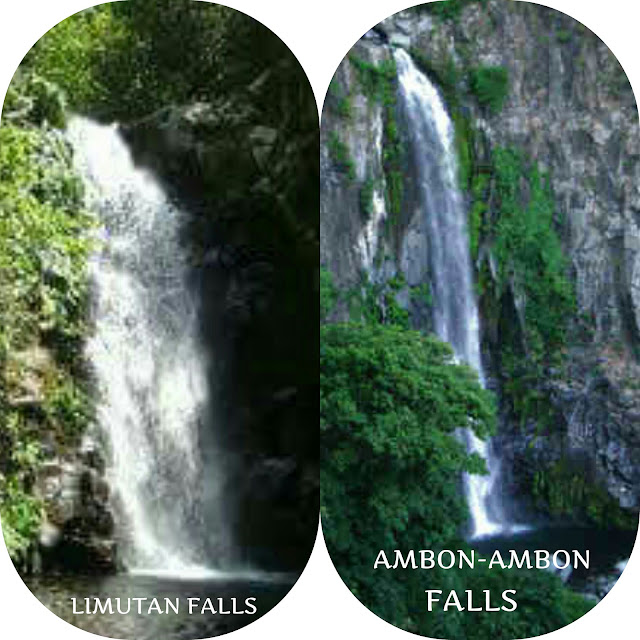
LIMUTAN / AMBON AMBON FALLS

The Limutan Falls and Ambon Ambon Falls are both located at Brgy. Binubukawan, Bagac, Bataan and the towering height of Ambon Ambon Falls is 60 ft while the Limutan Falls is 20 ft height. You can reach the falls by trekking about 10 kilometer away from the main road of Bagac approximately 1 to 2 hours or by hiring 4 by 4 truck.
Image result for saint catherine of alexandria parish in bagac
SAINT CATHERINE OF ALEXANDRIA PARISH (BAGAC)

Saint Catherine of Alexandria is the most beautiful church in the people because no architectural design. And this church made out of aged old stones with a vintage structure design this church was established bi Spaniards Fiars in 1872. During Nov. 23 they celebrated their feast by holding events and happenings.
Image result for las casas filipinas de acuzar in bagac bataan
LAS CASAS FILIPINAS DE ACUZAR

Las Casas Filipinas de Acuzar is unique Spanish-Philippines heritage site located in the town of Bagac, Bataan. It goes 22 mansions built from the 17th through 19th century spanish colonial period. The spanish word "casas" means house. Following meticulous process, each bricks tile , plank door and window made the long journey to Bagac, Bataan. This site was conceptualized by Mr. Jerry Acuzar a businessman and developer. In 2010 this site was opened to public. And they have some activities that you can do in Las Casas like visiting on Heritage Historical Tour, biking, kite flying, throwing parts, billiards, eating at Spanish, Filipino and Italian cuisines, enjoying on the beautiful scenery and etc.

Image result for bagac bataan friendship tower
BAGAC FRIENDSHIP TOWER

The Philippine-Japanese Friendship Tower reminds us of the friendship we have of Japan and symbolizes that the war between the two countries has indeed ended, that is why it is very significant to the Philippine history.
The tower was inaugurated on April 8, 1975 and is located about 200 m from where the Bataan Death March started.


Bagac Tourist Spot

Bagac Tourist Spot


Sabado, Hulyo 22, 2017

Pilar Tourist Spot

Local Attraction and Landmarks in Pilar


The place was named in the honor of the image of Our Lady of the Pilar, hence the town was called "Pilar". It is one of the oldest town of Bataan and previously it was part of Pampanga Spaniards in the galleon landed in a sitio of Balanga and were greeted by the natives.

It locate in the southeast portion of the Province of Bataan that approximately 2.22 kilometers from the city of Balanga, Provincial Capital. It is bounded by the City of Balanga (North), Orion (South), Manila Bay (East) and Bagac (West). It has an land area of 4, 520.23 hectares having a no. of household of 8, 365 and the average HH size of 4.96.

Pilar is subdivided into 19 Barangays:
Ala-uli
Bagumbayan
Balut I
Balut II
Bantan Munti
Burgos
Del Rosario (Poblacion)
Diwa
Landing
Liyang
Nagwaling
Panilaw
Pantingan
Poblacion
Rizal (Pobmlacion)
Santa Rosa
Wakas North
Wakas South
Wawa

On March 10, 180, Pilar was familya barrio within the jurisdiction of Balanga. It became a regular parish through the initiatives of the secular clergy and it was declared as an independent municipality on April 10, 1801

Because the town was the site of the bloodest confrontations between the invading forces of the Japanese Imperial Army and the defending American and Filipino soldiers during World War II that is why Pilar called the " Last Bastion of Democracy in the Philippines".

Image result for Mt. samat in bataan
MT. SAMAT NATIONAL SHRINE OR DAMBANA NG KAGITINGAN
Mt. Samat is located in the town of Pilar, Province of Bataan. It's cross was dedicated to soldiers who fought for freedom in the Battle of Bataan (WWII) designed by Lorenzo del Castillio and Napoleon Abueva made in steel and reinforced concrete finished with chipped granolithic marble with the height of 92 meters, lenght of 90 feet and with the width of 18 feet. It begin to construct on 1966 and complete on 1970.
Related image
BATAAN WORLD WAR MUSEUM
The museum houses several panels of infographic detailings tyhe process of war in the Philippines, a few donated artifacts and a huge diorama made up of 120 DOLLS desipting sence from the infamous Bataan Death March. Right outside the museum is the Surrender Site Monument where larger than the life statues of four American and there Japanese officers discussing and singing the surrender of the USSAFFE (United State Army Forces in the Far East) in the Philippines is loacted.
Related image
WETLAND AND NATURE PARK
Wet Land and Nature Park host a thousands of migratory birds almost everyday during the season. It is considered the magnificence of well-diversified bio network. The local government build a sanctuary for these birds and to protect them from being hunted and killed. These site is not only a alley but haven for for these creatures. And because f the birds that migrated the municipal of Bataan creates a festival (Ibong Dayo Festival) where in the people is celebrating and give admiration to migratory birds.
Image result for dunsulan falls pilar bataan
DUNSULAN FALLS
Dunsulan Falls is located at the foot of Mt. Samat Before you to come in you need to pay the entrance fee P50 for adult and P20 for children. In inside they have a large picnic grounds at the murky green water of the catch basin of the falls. It is quite noticeable that isn't much water pouring as it almost the summer season. At the falls they have a sign which says you can't seem near the drop of the falls, because of the hard rock at the surface of the falls and the shape is like a cone. And there was a reported incident to it.

Related image
OUR LADY PILLAR OF PILLAR CHURCH
Our Lady of Pillar Church is one of the interesting site that will preserved adobe structure with its belfry located on top of the main facade. By year of 1834 the said church was started to construct. It happened after the storm led the Spaniards to this place. And in the present day, the church stands strong for the local pilgrims and tourists. The feast day, celebrated by October 12.


Sabado, Hulyo 15, 2017

6 Famous local attraction and land marks in Abucay


Abucay is one of the 12 municipalities of Bataan Philippines. It has a total land mass of 7, 972 hectares. Located in the mideastern  portion of the peninsula bounded to the north by the town of Samal, to the south by the city of Balanga: to the east by the Manila Bay: and to the west by the town of Morong which shares the mountain areas with Abucay.

For some years, the town was called Santo Domingo. In 1646, it was called by its original name, Abukay. It became the initial center of the Dominican mission in Bataan which covered the area from Orani to Orion, then known as Partido de Batan.

At the present Abucay is a third class municipality and comprised of nine villages. The coastal village of Wawa, Omboy, Capitangan, Calylayan, and Mabatang. The large portion of Abucay's land areas is devoted to farming and fish ponds. The total agricultured area is 2, 293 hectares of irrigated and unirrigated land planted to palay, vegetables and root crops. The existing fishponds includes milkfish, tilapia, plapla, prawns and mud crabs.

 Abucay is a developing town. The past six years (1998-2004) have brought tremendous changes in the once-sleepy locality. Under the leadership of Mayor Liberato P. Santiago Jr. , three new boulevards connecting the old national highway and the Roman Expressway have been opened and are continuosly undergoing improvements. Since then, new communities have sprouted where these new roads traversed, opening more opportunities for macro and micro businesses.

The name Abucay was coined from ''Abukinaykay'' which means digging debris of five. According to legend, a spaniard came to this town and asking for its name. It so happened  that his arrival coincided with the just extinguished big fire that burned and destroyed quite a number of houses in the place and so the people were busy digging the remains from the ashes. Digging or shoveling, ''kinaykay'' in local dialect. So when this Spaniard asked from the name of the place the residents replied. ''Abukinaykay'', thinking that this Spaniard was asking what they were doing. From then on this town was called that way and later on to Abucay.
Image result for tomas pinpin monument in abucay
TOMAS PINPIN MONUMENT

This monument was built in memory of the first Filipino printer. It was in Abucay Church were Tomas Pinpin co-authored and printed the earliest books in the country with Father Blancas San Jose in 1610. Tomas Pinpin was born on between 1580 and 1885 Abucay, Bataan, Captainary General of the Philippines. Tomas Pinpin who was the first Filipino printer and is sometimes referred as the "Prince of the Filipino Printers".

Related image

SAINT DOMINIC PARISH CHURCH


The Saint Dominic Parish Church is a 17th Century Baroque Church located at Barangay Laon, Abucay, Bataan, Philippines. Built in 1587 that seen the deaths of more than 200 peopl, mostly pampangenos during the Dutch Invasion on June 16,1647. The present church was badly damaged by the earthquake of september 16, 1852. It is one of the oldest churches in the Philippines.


Related image

MARIA CANON STATUE

Maria Canon Statue was built by Mie-ken Daiichi Shueesee of the Japanese Sohtohshuh sect in September 1970 and it is located in Sibul Spring, Gabon, Abucay, Bataan, Philippines. A monument erected for the repose of  many WW II dead souls on the fields of Gabon, Abucay, Bataan.

Image result for sibul spring abucay bataan

SIBUL SPRING
It has a refreshing and cool water from the natural spring that believed able to provide muscle pain because of sulfuric swimming fools. It is located in Gabon, Abucay, Bataan.

Image result for pasukulan falls abucay bataan history
PASUKULAN FALLS

Based on our research it is a natural wonder located in Sitio Pasukulan, Barangay Salian. It forms part of the reaches of Tiawir River at the southern edge of the smaller Caldera east, southeast of Mt. Natib. With approximately 60 meters in height, it is one of the highest waterfalls within Btaan Natural Park. The cascading of water on the rocks adds drama to the beauty of the waterfalls.

Image result for paskuhan sa mabatang
PASKUHAN SA MABATANG

Mabatang its biggest and most progressive Barangay, is toutedas the christmas capital in Bataan for their annual christmas decoration competition. Paskuhan sa Mabatang, December 15 to January. It shows the creativity and ingenuity of the people in this much awaited season.


Bagac Tourist Spot

Bagac Tourist Spot Bagac is the largest  municipality in Bataan in terms of land area with approximately 23,120 hectares  (231.2km2) ...